#DefraData's Tim Ashelford compares his first experiences with free and open source geographical information software QGIS with proprietary alternatives. He is joined by QGIS pro Alexandra Kilcoyne from Natural England.
In the Defra Group we collect and use a lot of spatial data. This data is used across the organisations for delivery, analysis and visualisation. We have a range of Geographic Information Systems (GIS) tools available to carry out these tasks.
Tim’s relatively novice perspective:
For as long as I can remember we have had access to the ESRI set of tools, currently provided by a Defra Group enterprise licence agreement. For most users, this means access to the ArcMap 10.2 desktop tools. These tools have provided great utility over the years.
In the Defra Group, use of open source software is relatively immature. Most users’ computers are locked down and approved software can only be installed by an administrator. The approval process for getting new open source software approved and installed was slow and involved. So for many users, open source software was simply unavailable. You’ll be pleased to read that things have moved on a bit. For GIS users, the popular open source product QGIS has now been approved and is now available to order through through our corporate procurement catalogue.
As a long term ESRI user I was keen to explore QGIS and I put an order in. At the same time I ordered 4GB RAM for my ancient but standard issue Lenovo X230i laptop. The extra RAM seems to me like a great inexpensive upgrade to my aging IT kit. I've not done any proper testing, but subjectively the extra RAM seems to help my machine cope with more demanding tasks.
My initials impressions of QGIS have been favourable. It loads up quickly on my machine and the tools seems intuitive to use. One significant benefit was the tools I wanted for some analysis work looking at similarity between 22 datasets were available out-of-the-box in QGIS. In ArcMap, all the same tools were not installed as standard and I also needed to have access to a specific floating licence extension which wasn’t available. Working remotely using ArcMap can be difficult when the connection to the licence manager server is lost and you are locked out. None of this is an issue with QGIS which works fine offline. On the down side, I don’t think QGIS is quite as stable as ArcMap is on my machine. QGIS has crashed on me, something ArcMap rarely does. I also find ArcMap better for producing images to go into reports. Having access to ArcGIS Online via our enterprise licence agreement and its integration with ArcMap is very powerful. I’ve previously used ArcGIS Online to quickly create webmaps which can be then shared easily both within Defra and externally over the internet.
Away from work, I’m involved in organising a number of triathlon events like Leeds & Bradford Triathlon Club Junior Aquathlon on 7 May 2017. Having the ability to install QGIS on my home computer along with plentiful open source spatial data will has been great for things like producing maps for race instructions.
So I wouldn’t like to be without either tool. If I can't do something with QGIS, then I find ArcMap can do it better and via versa. It's like having a bigger better toolbox! I’d encourage other ArcMap users to give it a go.
Alex’s expert view:
For me, Tim’s hit the nail on the head with his point about comparing what ArcGIS and QGIS have to offer. Moving forward is about actively encouraging colleagues throughout Defra to look at the tools available to them – both commercial and open source – and to make an informed decision about the best tool for the job. 90% of the time I will head straight to QGIS – I’m more familiar with the tools and I know just how versatile it can be. However, there are occasions I know to use the commercial equivalent. Tim also commented on how intuitive QGIS was as a first time user – I’ve heard this so many times with QGIS. You might also want to compare the time it takes for each program to open – I know most of my ArcMap colleagues will walk away to get a tea/coffee while waiting for ArcMap to boot! QGIS, due to its ‘light’ infrastructure is considerably quicker. This difference is likely to be even more pronounced on computers with lower RAM.
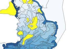
In Natural England, QGIS use is growing rapidly. The key areas I’m aware of are earth observation, data cleaning and big data processing. In the Evidence Earth Observation Service, QGIS and other open source tools like R and the European Space Agencies SNAP Toolbox have been heavily relied upon to create a habitat map for North Devon and Cumbria.
The 'Living Maps' project is due to be completed by the end of March with the aspiration for it to be released as open data – watch this space!
Natural England have even invested in QGIS training via the GIS 24/7 program – a recognition that QGIS has its place amongst the GIS software in government today. QGIS also gets a mention in the Defra GI strategy – I look forward to seeing more new users like Tim throughout the group.
1 comment
Comment by Andrew Scaife posted on
Tim's comments about extra RAM for his laptop raised a wry smile with me. I argued at the time we were all going to receive our x230i laptops that the 4 GB was inadequate for data-intensive work, but I was ignored. In Food and Farming Stats we are beginning to realise that there may be life beyond Redmond (and other closed-source providers) but it's a slow process. Nice to hear that open source is getting a foothold.