GeoSmart Information combines Environment Agency open data with modelling in its GWFlood groundwater flood forecast service.
Our model
At GeoSmart, our model predicts groundwater levels based on actual history of all the main variables affecting groundwater recharge, flow and discharge to the ground surface and rivers across much of England.
The model uses the next 10 days’ weather forecast to determine the potential groundwater level during that period, and then looks further ahead on the basis of historical average weather to extend the forecast to any future date of interest. Levels and likely flows are reported probabilistically against the location of assets, such as property or critical infrastructure to indicate the likelihood, timing, duration and severity of future flooding.
As with any projection model, the further ahead you look, the more uncertain the outcome. Because of the importance this particular model gives to groundwater, and given the long slow pathways of groundwater flows, flooding events can be predicted further into the future, giving valuable early visibility on this significant part of the flood hazard faced particularly in the more permeable catchments of southern England.
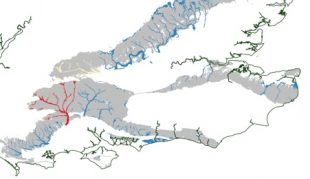
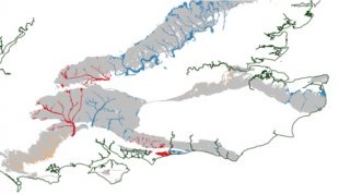
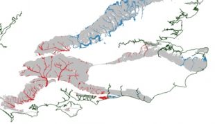
The model was run for part of southern England to demonstrate capability for predicting the severe groundwater driven flooding events of 2014. Figure 1 shows the 30 day forecast for 1 January 2014, showing that flooding in parts of Hampshire by the end of the month was already more than 80% likely to happen by the end of that month. Figure 2 and 3 show how the probability of flooding increased over the subsequent fortnight. The forecast provided a close match to actual events during the major flooding period of February 2014, showing that the model is a powerful prediction tool, bringing a significant increased visibility of upcoming events that could make a real difference.
In practice
The flood forecast service is now running operationally, providing daily updated forecasts of the likelihood, timing, duration and severity of flooding from groundwater, and the potential impact on assets such as tunnels, sewage networks and other structures.
At GeoSmart, we’re working with the Flood Forecasting Centre delivering a pilot implementation to support the FFC early warning service. Now in its second winter of trials, the service is delivering earlier visibility and enabling improved preparedness to the nation’s first and second Category 1 and 2 emergency response community, Environment Agency and other organisations that need to manage flood risk.
GeoSmart deliver a daily updated forecast http://geosmartinfo.co.uk/services/gwflood/ currently covering some of the major centres of population in southern England as a subscription service for infrastructure organisations and others needing to plan ahead to ensure operational resilience. GeoSmart has also developed a further model to provide live sewer infiltration forecasting service http://geosmartinfo.co.uk/services/gwsewerflood/, and this is helping water companies and others to further reduce sewer infiltration from groundwater.
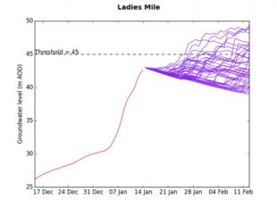
Figure 4 shows model outputs for Ladies Mile – a location near Brighton – for 14 January 2016. The red line shows the history of actual groundwater level at a key indicator borehole location, and the purple lines present the range of outcomes from the probabilistic model, which are captured in the forecast in terms of timing, likelihood, duration and severity of groundwater flooding.
In the case of this 14 January 2016 forecast it can be seen that flooding by groundwater emergence locally was seeing rapidly increasing likelihood from late January. By analysing the longer term profile of response, the timing of initial impact, severity, and likely duration of flooding was predicted by the model.
This innovative service for the first time provides predictability of a significant component of flooding, bringing a powerful new tool to those that need it. The capability for prediction, rather surreally, even extends beyond the weather forecasting horizon (usually recognised at 10 days) because of the long ‘groundwater lag’ in large catchments.
This world class innovation provides an excellent example of the power of open data, being entirely driven data from diverse sources. It was delivered in just 3 months.
For more information markfermor@geosmartinfo.co.uk or visit http://geosmartinfo.co.uk/services/
Recent Comments