On World Soil Day, Naomi Lees explains the importance of Defra’s new four-year agreement with Cranfield University for the maintenance and licensing of the Land Information System (LandIS).
LandIS is recognised by the UK Government as the definitive source of national soils information for England and Wales, and access to this resource provides the Defra group with invaluable data. The data it provides is being used on a number or projects and policy areas across Defra, helping to inform our soil, future farming and environmental policies to meet government ambitions.
As a Data Resources & Licensing Manager, my role in Defra involves negotiating contracts and licences for access to key data resources from third party organisations. This includes negotiating and managing our contract with Cranfield University for the maintenance and supply of LandIS soil data. As Defra and Cranfield University jointly own the Intellectual Property Rights in LandIS, the agreement we have been working on reflects how we will continue work in partnership to maintain this important resource.
Cranfield has a world-leading role in driving agricultural innovation and development. In 2017, Cranfield was awarded the Queen’s Anniversary Prize for its research and education in large-scale soil and environmental data for the sustainable use of natural resources in the UK and worldwide. As soil health is central to delivering our objectives on biodiversity and profitable agriculture, LandIS continues to be a key resource for the Department.
What data does LandIS contain?
LandIS contains the following soil mapping, soil property, and agro-climatological data:
- Spatial mapping of soils at a variety of scales from national to field level, supported by over 250,000 field observations
- Corresponding soil property (from over 30,000 soil samples) and agro-climatological data
- Information on soil erosion, land use, and lithology
- Over 12,000 detailed soil profile descriptions
- Measurements of over 20 elements of topsoils, in addition to pH
- Soil texture data
- Depth data to various layers and flood risk indicators
Uses within Government
LandIS is a valuable resource for government agencies and departments involved in a wide range of activities, including:
- Land use planning: LandIS data can be used to inform decisions about land use planning, such as land capability for agriculture (Agricultural Land Classification), where to locate new housing developments, or infrastructure projects.
- Environmental protection: LandIS data can be used to identify and protect sensitive soils, such as those that are at risk of erosion or compaction.
- Agricultural policy: LandIS data can be used to develop agricultural policies that support sustainable farming practices and protect soil health.
- Climate change adaptation: LandIS data can be used to assess the vulnerability of soils to climate change and develop adaptation strategies.
Uses within Defra and beyond
I’ve listed below some specific examples of how government agencies and departments are using LandIS data. There are many others, but I hope these provide a strong flavour of the benefits we get from this data:
- Defra is using LandIS data to develop soil health indicators and a new land use framework.
- The Environment Agency is using LandIS data to identify and manage flood risk.
- Natural England is using LandIS data to inform its work on biodiversity conservation.
- The Forestry Commission is using LandIS data to plan for new woodland planting.
- Local authorities are using LandIS data to inform their land use planning decisions.
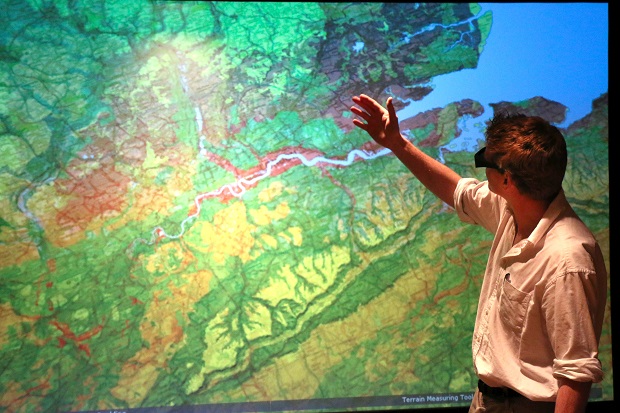
Case study: Natural England and LandIS
Natural England is using LandIS data to help develop an improved peat map for England, available free to use, which will help better understand greenhouse gas emissions, support nature recovery, target peatland restoration and help with natural capital accounting.
The current best product showing the extent of peaty soils in England is derived in part from Landis data, but it only tells us where peaty soils are located. Extensive surveys are now being carried out which will improve our knowledge of where peaty soils are, determine their depth, tell us about erosion and drainage and what is growing on our peatlands.
Not all peaty soils occur at the surface making them particularly hard to find. For instance, clayey soils in the Cambridgeshire Fens sometimes have thick layers of peat underneath. Natural England uses LandIS soil association data to tell its surveyors where to look for these hidden peatlands.
The surveyors record any peat they find in the first metre of soil. Not enough is known about how buried peats are responding to the changing climate and changes in water table. This new data will help us identify where they are and how best to look after them.
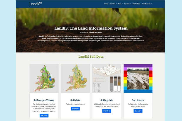
Useful tools and resources
LandIS provides a number of specific tools and resources for government users, including:
- Digital Soil Dataset Families: Soil and soil-related datasets, including The National Soil Map and soil attribute data
- Soil Site Reporter: An easy-to-use online tool that produces site-specific soil information with maps and descriptions.
- Soilscapes: A freely available online resource that offers soil overview information at a relatively basic level.
- Online soils guide: An interactive tool that can be used to explore the various soils of England and Wales.
- Range of other services: From detailed downloadable soil reports to professional consultancy services.
To find out more about LandIS and access datasets, please visit the LandIS website or send us an email.
Naomi Lees is Data Resources & Licensing Manager within the Data & Information Access team in Digital, Data and Technology Services.
World Soil Day 2023 (WSD) and its campaign aim to raise awareness of the importance and relationship between soil and water in achieving sustainable and resilient agrifood systems. WSD is a unique global platform that not only celebrates soils but also empowers and engages citizens around the world to improve soil health.
Check out our LinkedIn page for all the latest blog posts and job openings. While you're there, why not give us a follow.
1 comment
Comment by George Watkins posted on
Very interesting subject, it ties in with all the flora and fauna.